Home › All Topics › Bugs › Incomplete road maps
- Ce sujet contient 4 réponses, 2 participants et a été mis à jour pour la dernière fois par
Aldwin, le il y a 12 années et 10 mois.
-
AuteurMessages
-
mars 27, 2013 à 4:41 #4061
Hello GeoMagik Team,
My name is Aldwin and I’m from the Philippines. I have purchased your app PocketEarth since I have read excellent reviews about it.
I’m still trying to familiarize myself with the map and downloaded the whole map of the Philippines. However, there’s one thing I’ve notice is that some of the roads are not compete and they are just dotted lines. I understand that PocketEarth was based on OpenStreetMap style so I went ahead and checked OpenStreetMap to see if those incomplete roads also appear as dotted lines there. They do not.
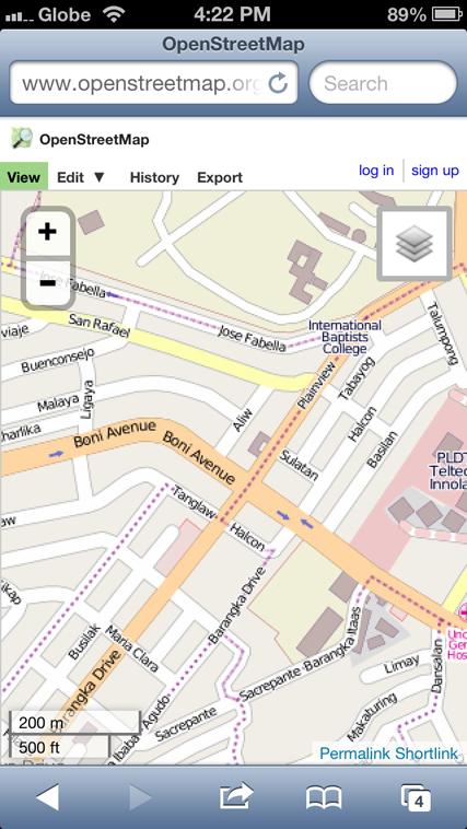
To show you what I mean, here are some screent shots of the map from OpenStreetMap’s site and on PocketEarth.
Here’s a screen shot of OpenStreetMap of an area near my place:
And here’s screen shot of the same area on PocketEarth:
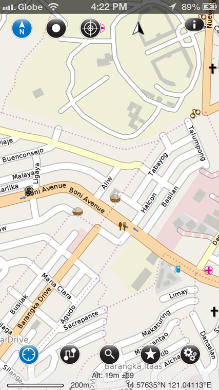
You will see that on OpenStreetMap, the road ‘Barangka Drive’ (lower left) is complete, while on PocketEarth, part of it only appears and the rest are just dotted lines. This is not the only road that appears as dotted lines. I already have the map style set to OpenStreetMap and have all the map layers turned on, I turned off the walking paths and bicycle paths, reinstalled the app and just downloaded the map of my city, but it’s still the same. I really don’t know how I can fix this. I hope you can help me with this.Thank you very much and I look forward to your reply.
Regards,
Aldwin
mars 28, 2013 à 3:14 #4563Thanks for contacting us and letting us know about this issue! It had not come to our attention before, but looks like this is a bug in our data processing. In particular these purple dotted lines represent political boundaries, and it seems there is a bug that when they happen to be along a street, the street is not appearing as it should.We will try to correct this issue as soon as possible and publish the updated maps.Thanks for letting us know, and sorry for the inconvenience in the meantime. I will let you know as soon as it is corrected!mars 28, 2013 à 3:22 #4564Thank you for the immediate response and thanks for letting me know that this is a bug. I hope that this issue can be fixed soon and I hope you can inform me when this has been resolved. So far, I’m very happy with PocketEarth!
Regards,Aldwin
mai 21, 2013 à 5:55 #4701@Aldwin, sorry I forgot to post back on this thread. The new in-app data update available with PocketEarth v1.5 greatly improved this situation by showing the missing streets (but not showing the dotted administrative boundaries). We are still working on a solution to show both.
mai 21, 2013 à 8:44 #4703Thanks for the info about the in-app data update. I can see that the
issue has been fixed even though you said that isn’t exactly fixed yet.
But I would prefer seeing the complete street roads over the purple
dotted lines.Thanks again and more power to GeoMagik and PocketEarth!
-
AuteurMessages
- Vous devez être connecté pour répondre à ce sujet.