Home › All Topics › Bugs › Favourite star now dark
- This topic has 41 replies, 5 voices, and was last updated 11 years, 12 months ago by
MikeB.
-
AuthorPosts
-
July 19, 2014 at 6:59 am #7279
This morning I found the new version of Pocket Earth and am still exploring it. Since I am leaving in two days for a trip, I looked there first to make sure everything was the way it was before. A bus stop I had saved as favourite is still there, but getting information about it showed the star is no longer ‘lit’ – it remains dark. However, when I touched it to mark it as favourite, it asked if I wanted to delete it. So, the star still ‘works’ but the status is now broken.
July 19, 2014 at 2:06 pm #7287Was the bus stop still listed under your “favorites” in the side menu? If so, it’s still saved. The star icon in the new PE is now solid gray when saved and simply a light gray outline when not. In previous versions of PE, the star icons were colored.
July 19, 2014 at 2:45 pm #7288I believe so. I can’t find it at the moment. I’m sorry to say I find this a completely useless and pointless change. Previously, it was easy to see what was saved as a favourite. It is no longer so easy to see this. Why “fix” something that was not broken??
July 19, 2014 at 3:57 pm #7289If it’s a bus stop, that means it was a POI (point of interest) already on the map and not a Pin that you added yourself. Open up the left-hand menu (on iPhone, iPod) and scroll down to the favorites section. You can choose either “All” or tap on “By Type” to expand the menu tree, and then choose “My POI”. If the bus stop in question is listed there, then you can be sure it’s been saved.
Another thing you can check is the “hidden” option. Find your POI and bring up the details pane; be sure the hidden toggle isn’t ON. If it is, it will disable the green outline around the POI icon on the map. For Pins, it will completely hide them from being displayed at all.
As for the color change, I can’t say for sure but if I had to venture a guess, I’d say the change is to be more in line with the direction Apple is heading; everything being flat, white and dare I say boring. The upcoming iOS 8 even features a monochrome mode that can make your device black and white?!! Why anyone would want a monochrome display in 2014 is beyond me but Apple has always tended to place a higher emphasis on form over function. Luckily it’s an option but it’s an odd choice seeing as there are so many other options they should be addressing first. Sorry for the rant, I’ll dismount my soapbox now.
July 19, 2014 at 4:10 pm #7290From what I can see, all my POIs are still there. The problem is what I wrote in the original post. Previously it was quite clear whether a POI was saved or not – the star was coloured making it quite clear that it was saved. Now, the distinction is very small and hard to notice. Frankly, I don’t care what Apple does. I care what Pocket Earth does. I’d suggest to revert to the previous condition. It makes more sense and is much, much easier to see.
July 19, 2014 at 6:44 pm #7291Well it’s good to know that your favorites weren’t lost in the upgrade to 2.2, otherwise that’d be a bug. As for the color of the star icon, I’d suggest starting a thread in the Feature Request section and perhaps the developers will be able to re-evaluate the change.
July 20, 2014 at 6:34 am #7300I can see how it might seem arbitrary but it was part of a larger change to greatly simplify Maps Management and Routing. Maps no longer have the confusing dual notion of being a favorite and/or being offline. They simply have a download or delete button. Routes and Tracks also no longer have a star as they auto-save and only need a delete button.
Pins and POI still have a star but we wanted to make it more consistent with our other buttons being flat gray. Now it is just a hollow or filled star.
E.G. Colored star no longer have a double meaning of offline cache status. Sorry if this was a confusing change!
July 20, 2014 at 7:31 am #7302Thanks for the explanation. I can understand the motivation, but I fail to see how one form of marking is “simpler” than another form. It seems to me that you need to be able to tell quickly whether a POI has been saved or not. You seem to agree with that by having a slightly different star depending on the status. All I am saying is that the difference between the saved and unsaved could be clearer. Having a different colour would be clearer.
I have also noticed that the zoom buttons (which I probably use more than any other controls) have been moved from the bottom of the map to the top. Since all other controls are on the bottom, I also find that not an improvement.
Having said all this, I am absolutely gobsmacked by how much better the routing has become! Using the same bicycle route from my house to a destination on the other side of the river now works perfectly! The auto vehicle rules are now ignored and the route it gives is very close to the route I have used myself. Very nice indeed.
July 20, 2014 at 7:45 am #7305Thanks for the feedback, we will reconsider the star button styling for our next update! v2.3 will be out in probably 2 weeks and include a unified search bar that searches everything at once.
We did change the layout of the map buttons on iPhone to make it more ergonomic for one handed use. Also to avoid a serious usability issue with pinching that numerous users had reported. Before though the left side zoom buttons were meant for right handed use, now the right side zoom buttons are meant for right handed use, and you may need to change the setting for this for it to “feel right”. Tap the settings button and go to More Settings. Then tap Zoom Buttons and change it to right side if you are right handed or left side if you are left handed.
Hope this works out for you, I think you will find it a much nicer layout once getting used to it.
Glad to hear routing is better now, the routing system alone had over 20 fixes and enhancements in 2.2!
July 20, 2014 at 8:25 am #7306Thank you. I hope the styling will be improved for the star buttons. Unlike the movement of the zoom buttons, this is something that I think both new and old users would appreciate having a sharper distinction between the two states.
I tried the zoom buttons. I am right-handed and the buttons on the right feel wrong. I put them on the left and they work better if I use only one hand. You might also offer the additional option of top or bottom, as well as left or right, since that would give users the best chance of finding a position that suited them.
There are a few other things I wanted to discuss and rather than spreading them into separate threads, I’ll put them all here.
- It would be nice if there were a better choice of icons for POI. Some of the icons used by OSM would be welcome.
- If making an existing POI a favourite, there are a few option not available that would be useful, such as editing the address or modifying the colour of the icon. I don’t know if this is possible.
- When looking at all my favourites, I see that many of them are already ‘tagged’ – that is, they show what they are. Could these tags be integrated into the group system you have developed? It would be great to just import the existing tags rather than having to duplicate each one manually.
- I’m not quite sure what to do about this, but many of the ‘nearby’ options are duplicated in the map layer options. The nearby does offer some more options (such as search), but I really wonder if both are needed. I assume the data is the same for both. I don’t have any request or suggestion here, but perhaps the difference (if there is one) between them could be clearer.
- I don’t think I’m the first or only person to suggest this, but I would very much like a routing system that would let me input manually. I could pick points, then the routing would only need to connect them. As I wrote in another thread, I’m going to Nice tomorrow and walking from a bus stop to a train station that is very tricky. As I wrote earlier, I base this on Google Street view which shows no pedestrian crossing in the route that has been chosen for me and also shows this is a very heavily (auto) traffic street, which means even trying to cross without a traffic light or pedestrian crossing would be near suicidal.
July 20, 2014 at 5:25 pm #7307I’m not sure I understand your issue in point no. 5
Having selected my departure and end points for a new route surely it is just a matter of pressing a finger on the route then dragging the resulting orange control point to a position you wish the route to navigate via – or am I missing something?
Attachments:
You must be logged in to view attached files.July 20, 2014 at 6:04 pm #7309Yes, I think you are. There are some instances when your method will work. However, there are other instances where it is simply too much work to drag several points around for an almost completely new route. The route in Nice is almost completely wrong. It would be much easier to mark three or four points and then have the app draw the lines connecting them.
July 20, 2014 at 6:34 pm #7310OK, I can see where you are coming from but I recently built a route from the UK to the south of France and back for a motorcycle trip. It was easy enough to keep adding destinations that were defined by using the map center option (cross hairs) A couple of time I got a bit out of sequence but it was just a matter of reordering the “destinations” with the “three bar” facility
I also used the shortest route preference to try and force the preety route!
July 20, 2014 at 7:18 pm #7312MikeB, in regards to your point #5, this can already be accomplished in PE using Pins. Let’s say you have 4 manually placed points you’d like to connect, do the following:
- Drop a Pin on the map as your starting point
- Drop your 3 additional Pins including your destination on the map as well
- Now tap on the starting Pin and tap the info bar at the top to bring up the details pane
- tap the route button and then choose “route from here”
- PE will now ask you to add a destination
- tap the info bar with the yellow exclamation
- tap “add destination”
- choose “select item on map”
- choose your next Pin and then tap the “+” symbol at the top-right and PE will generate a basic route
- you’ll still be looking at the details pane so now scroll down and choose “add another destination”
- follow from step 8 and add your remaining pins in the order you wish to build your custom route
I should also add that you’re not restricted to Pins; if you have POI’s along your route, you can use those instead and save yourself a bit of time. You can also use a combination of both or even street addresses, favorites and contacts as well.
Be advised that you can re-arrange the points of the route at any time by bringing up the route details screen and then scrolling down to the “route planner” section. Simply touch and hold the triple line icon to the right of each item and drag them around to whatever order you wish. PE will then re-generate the route accordingly
July 21, 2014 at 9:07 am #7315- We do offer the full OSM icon set via the OpenStreetMap stylesheet in settings > More Settings > Map Style.
- We do plan on allowing users to add public POIs in a coming update to help fill in missing data. This will likely be independent of OSM data because we want to allow things like ratings, reviews, and photos which OSM doesn’t support. However, we feel its less confusing to use a standardized set of colors and icons for POI categories.
- Very good idea! We will consider best way to add POI Category filtering for favorites.
- Yes there is a lot of overlap between the two, but currently they need to stay separate. They are built on fundamentally different understandings of the POI objects. They also are meant to serve different purposes. Nearby is for searching through the nearby POI data while the Map Layers are for the styling of the POI and other OSM data.
- Sounds like you are talking about simple straight line routing, not requiring any route fetching from the server. If so, we have had some requests for this and are planning to add support for it at some point.
July 29, 2014 at 6:28 am #7349Hi, I am just back from my holiday. I was very happy to have Pocket Earth with me as it was very helpful in locating areas better than a paper map. We had a map of our holiday apartment location, but without GPS and Pocket Earth, it would have taken much longer to find it (it was in an old village and not all streets had names).
On the point number one: I have tried the setting you mentioned and see no difference. Do I need to restart my iPhone?
On point five: using the route in Nice as an example: the distance is quite short – perhaps 200 meters. Ideally, I would like to set pins, perhaps numbering them 1, 2, 3, etc., then tell Pocket Earth to draw a route from Pin #1 to Pin #5 (last pin) and it would follow the numbers to make a line. You are correct that no server would be needed to do this.
I haven’t used Pocket Earth much for routing since, when I travel, I mostly use public transport or foot. The routing in Nice was complicated because there was not a straight line to walk. There was also very heavy traffic in mid-day when we were there. Using Google Street View, I made a route by just setting pins along the path. Once we were there, it was easy to see the correct path based on my plan. The route from Google Maps and Pocket Earth did not follow the zebra crossing, which was perhaps 30 meters in the opposite direction from the goal.
July 29, 2014 at 2:59 pm #7353MikeB
Changing the map style to OpenStreetMap, you should definitely be seeing a difference as it uses the POI symbols from OSM.
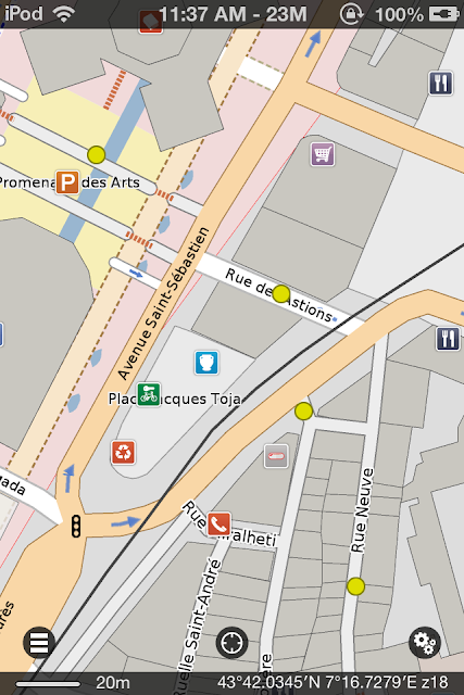
As for your routing idea about dropping Pins and having PE connect the dots, see my last post just above with instructions. Here’s an example of a 214m walking route in Nice I made using 4 Pins placed manually.

BTW, I didn’t realize there are zebras in Nice and that they have their own street crossings. I kid, I kid. 🙂
July 30, 2014 at 3:02 pm #7356XOMTOR
Thanks for the info. After switching to the other view, as Geomagik told me how to do, nothing changed. However, today it seems to have worked. Sometimes (generally, not only with Pocket Earth), I have found that things don’t change immediately, but do the next day.
On the routing, it did not work for me. I had made three pins each with a different number. I have uploaded two screen shots: #1 is the plan without a route, the three grey circles are the steps I must take to reach the goal. #2 is the plan made by Pocket Earth. As you can see, they are quite different. The plan made by Pocket Earth would not work because there is no zebra crossing, no traffic light, but there is a fence preventing people from crossing part of the last part of the plan. I told Pocket Earth to make a route starting a POI #1 and end at POI#3. It ignored POI#2, which is why I suggested the self-routing should work as I wrote.
Attachments:
You must be logged in to view attached files.July 30, 2014 at 4:01 pm #7361Good to hear that you were able to finally see the OSM POI icons.
Concerning your routing issues, I believe the reason PE ignored one of the pins is because it’s placed on a street that is labelled in OSM as private access; that’s what the pink dotted line is representing. I just checked OSM and looks like it’s a bus lane as it’s tagged with these attributes:
access:no
bus:yes
highway:serviceThe “access:no” attribute will prevent any router (online or otherwise) from calculating a route over such a feature.
July 30, 2014 at 5:03 pm #7362That looks to me like a problem with both the tagging and the interpretation of the tag. I have enclosed a screen shot from Google street view that 1. clearly shows an auto using this lane and 2. if a street is labelled as a bus lane, where is it written that people walking cannot cross it??? As the screen shot also clearly shows, there is a zebra crossing on the street that this tag forbids. I just don’t understand this. If the city of Nice puts a pedestrian crossing there, why then is it forbidden by OSM or whoever makes these tags?
And, finally, as I was there only a few days ago, I can confirm that the street view is accurate.
Attachments:
You must be logged in to view attached files. -
AuthorPosts
- You must be logged in to reply to this topic.