Home › All Topics › Bugs › Favourite star now dark
- This topic has 41 replies, 5 voices, and was last updated 11 years, 12 months ago by
MikeB.
-
AuthorPosts
-
July 30, 2014 at 5:52 pm #7364
I would also like to add that the routing I attached as “2.png” in my message above, suggests crossing exactly the same street that is tagged as “access:no” and furthermore, as the attached screen grab shows, does not have any sort of pedestrian crossing and has fences on both sides of the street to prevent people from crossing.
So, the routing says not to cross where there is a pedestrian crossing and yes to cross where there is none. I do not understand this type of logic at all.
Attachments:
You must be logged in to view attached files.July 30, 2014 at 6:54 pm #7366It could very well be an incorrectly tagged; OSM isn’t perfect. Here’s a screen grab from street view that shows the driving lane in the foreground and the bus lane in the middle ground.

If the bus lane is in fact drivable by regular passenger cars, then yes OSM needs to be updated. Since OSM is a community driven effort, you can make the change yourself if you’d like by signing up or you can submit a report and a mapper in the area can take a look at it.
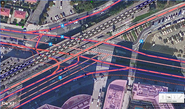
Here’s a screen grab from the OSM editor showing an aerial view; you can see the dotted red line which represents the bus lane. You can also see the separated East-West auto lanes on either side.
In regards to crosswalks, they are rarely mapped. They certainly can be but like most mapping databases, routing is primarily geared towards motorists. OSM does have OpenCycleMap geared towards cyclists but there’s no subset dedicated to pedestrians navigating city streets on foot. Even when crosswalks are mapped, they’re usually simple ‘nodes’ and I don’t think any routing service pays attention to them.
Ultimately, the reason one of your pins was ignored is simply because it was on the other side of Boulevard Rene Cassin and at that intersection, there’s no rout-able connection between the East and West lanes. At that intersection, cars can only make right-hand turns and head East. Basically, no connection, no access to the other side of the road as far as a router is concerned. In order for a routing service to navigate a crossing at that spot, a footpath would need to be drawn and tagged as “highway=footway” and connected to either side of the road. Again, that’s up to the mappers in the area and how dedicated and detailed they want to be.
July 30, 2014 at 7:59 pm #7367Thanks for your most recent screenshot; it clearly shows that the center bus lane is correctly labelled in OSM. You can see the telltale red circular warning signs on either side of the lane.
As to why it routed you across a street where there are clearly barriers, well OSM like most mapping datasets and routing services sorta assume that pedestrians can typically walk along the sides of most roadways (plus those barriers aren’t mapped). Again, OSM could be drawn with a level of granularity required to support much better pedestrian routing but I don’t think that’s a very high priority on most mappers to-do lists. I’m a heavy OSM contributor in my area and I rarely even give much thought to cycling routes as it’s not something I’m interested in nor is it something that’s too popular around here. You can infer from that how much thought I give to pedestrian routing.
As for the bus lane being tagged with “access=no”: that won’t prevent a crossing of that route, it simply prevents a router from generating a route along it. By placing that gray pin on that bus lane, you were essentially asking the router to generate a route along it and it came across the tag “access=no”. When it comes to navigation, a routing service can only plot a course along “ways” (a fancy word for lines on a map). So there needs to be a road, highway, path, track, stairs, bridleway etc. and they all need to be connected and tagged with the proper tags. A router won’t be able to simply “jump” you from the East to the West lane of Rene Cassin as it’s currently mapped. Now that I’ve looked at the map in the editor, I can see that someone has mapped some of the sidewalk and the crossings on the East side of the street but they haven’t completed making the connections to the West bound lane.

I’d do it myself except that the aerial imagery is not very good at that spot so it would be best to leave it to a local mapper with “on the ground” knowledge of the area. Luckily, a mapper has made changes to that exact footpath only 25 days ago so the area is actively being worked on.
July 31, 2014 at 7:20 am #7377The way I see this is that there are not one, but two elements to the “tagging”. One is that they must be “correctly” tagged. The second is that the program supporting them must interpret the tag correctly. To use the street in front of my house as an example, it should be (and is) tagged for both autos and bicycles. However, when interpreting for autos, it should be restricted to one-way, but for bicycles, it should ignore the one-way rule since both bicycles and pedestrians do not need to follow traffic laws.
By focussing on autos, however, they are doing a great disservice to travelers of other types of transport. So, for example, when you wrote: “By placing that gray pin on that bus lane, you were essentially asking the router to generate a route along it and it came across the tag “access=no”” this is a disservice to pedestrians since the city of Nice not only has a pedestrian crosswalk there but also has traffic lights to stop the autos (or buses) when people are crossing.
Secondly, why does the routing service check a route that is manually input?!!! If the routing service worked properly in the first place, I wouldn’t need to put the route in manually, but it doesn’t. But the whole point of inputting a route manually is that it is an alternative to a route which, as you correctly pointed out, is focussed on auto drivers, not bikers or pedestrians.
And finally: as I pointed out several messages ago, when the routing service made the route (unrequested), why did it prevent the route from crossing at an existing crosswalk and put in a fictional crosswalk on the very same street??? How can a street be tagged for both yes and no?
July 31, 2014 at 1:38 pm #7378I agree with almost everything you’re saying about proper tagging and to some degree about focusing on auto routing; however your arguments would be better directed towards the OSM community. PE simply uses the data from OSM.
As for the need to calculate a route based on manually input points, I would hope that even a program that has the ability to generate routes “offline” would follow the data we put into OSM. We don’t need or want apps to be overriding the information in the database using their own ‘fuzzy logic’. Of course it’s up to the developers of Pocket Earth if they want to program in that type of liberty but I would hope not.
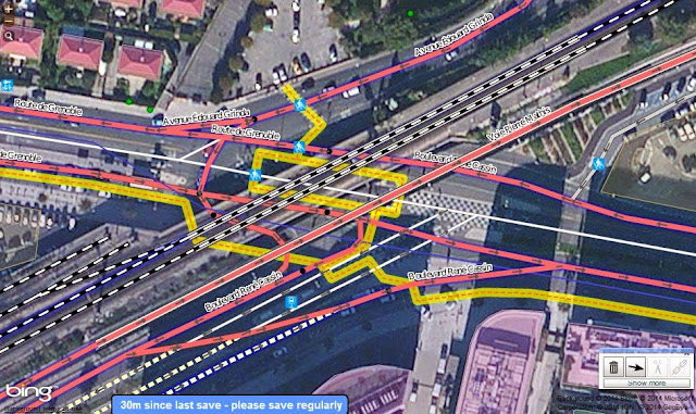
And finally, in the case of crossing Rene Cassin on the east side of the overpass, as far as OSM, the routing service and the app are concerned, there IS no crossing at that particular point. It’s not a feature on the map at this moment in time. But to illustrate how it needs to look in order for your route to work, I’ve gone into the OSM editor and drawn in the sidewalks and crossings. Compare it to the last screenshot I posted above.
Unfortunately I’m not going to save the changes to the database for 3 reasons:
- I had to make extensive use of Google Streetview to get my bearings and that’s against OSM’s principles.
- I don’t live in the area so I’d be an ‘armchair’ mapper and since there’s already someone else working in that area, I’ll leave it to them.
- I’m not convinced that OSM needs to focus on the routing of pedestrians and neither do many in the community. At this time, in order for routing to work properly for pedestrians, it requires mapping sidewalks as separate ‘ways’ creating what essentially amounts to a trail network along the sides of existing roads…yuck. This is viewed by many to be redundant (especially in an urban environment) and the hope is that in the future, proper tags can be developed and that routing servers will be able to correctly interpret them. It will take time for this to all come together. As it stands now, streets are basically assumed to have sidewalks on either side unless it’s a major highway. That’s why you were routed the way you were.
July 31, 2014 at 2:21 pm #7379I do not think that OSM needs to focus on pedestrians, I think it needs to de-focus on autos.
That is: give equal attention to the three main types of transport: walking, biking, driving. As I wrote above, I really don’t see the issue. I don’t know what the “access” tag means. But I don’t see a problem with being able to “tag” a street for auto, bicycle and pedestrian. Each tag could have a sub tag which would describe any restriction to that form of transport. So, for auto the sub tag might be one-way. The bicycle and pedestrian tags might be open (meaning any direction or no restriction).
The problem with Pocket Earth, however, is quite clear: inputting a manual route should NOT communicate with the routing server. I’m not a programmer, but if items are placed in numerical sequence, I don’t see the problem in simply asking the program to draw lines following the numerical order.
August 1, 2014 at 12:43 am #7390With enough contributors, the possibilities for OSM are almost limitless (well at least as far as mapping goes).
Regarding tags, OSM already has tags for all those things you mentioned. Unfortunately the bus lane is simply tagged with “access=no” by a local mapper. It may as well have been a road within a military complex. 😉 Seriously though, it’s probably incorrectly tagged.
I see your point that you’d like for Pocket Earth to have the ability to simply connect points and ignore the need for distinct ‘ways’ but that’s up to the app developers. My vote would be a definite no as it’s taking liberties with the data or in this case the lack thereof. If they are to include such a feature, it should be a simple ability to mark-up the map to create a makeshift route. It should not be shareable nor have the ability to be exported as a GPX file; essentially it should exist as a sort of personal note within the app that’s “for your eyes only”.
August 1, 2014 at 7:12 am #7391Your faith in anonymous contributions is very idealistic, but, to quote something I read from a perhaps more realistic Internet observer: “There is more information publicly available today than ever before thanks to the Internet. And more lies.”
Since you haven’t responded to several points I’ve made, I’ll assume what your response would be. The “access=no” tag, I assume, refers only to autos but is incorrectly transmitted (or incorrectly tagged) when a pedestrian route is requested.
I could not disagree more with your last point. If the routing worked correctly (and you’ve admitted that it does not in at least this case), there would be no need to make a “personal” route. Sometimes, I can well imagine, especially a local person, may know a shorter way of going or an easier way of going than the routing service. Why should that information be kept private?
I have seen some ludicrous faith in technology. A Polish lorry driver needed to bring some goods to Manchester in the UK. His GPS routed him through the heart of London during the morning rush hour. He followed it. A tourist wanted to hire an auto and drive from Amsterdam to Brussels. When people told him it was much faster by train, he responded: but Google routing says it only takes only 90 minutes. Of course, Google has never actually driven the route, while local people have, but this tourist apparently trusted Google more than local people.
There is a lot of great new technology around today, but that does not mean that realistic perspective is no longer necessary.
August 1, 2014 at 7:37 am #7392I believe the access=no tag applies to all transport modes including pedestrians as per the OSM wiki page about it. This can be overridden for pedestrians by specifying a foot=yes tag. There are also tags for cycling and oneway only access by transport type. I am pretty sure though that these only apply to movement along the street, and has nothing to do with crossing streets. The cross walks should be tagged so the router knows where it is possible/legal to do so. There may be assumptions by the router about which kinds of streets are cross-able anywhere vs ones that can only be crossed at designated crosswalks. I am not myself that familiar with these details of OSM yet.
The OSM project has come a long way but it is far from perfect. It has a huge community though and is rapidly improving.
August 1, 2014 at 8:39 am #7393I think a big problem with the OSM is that it may be too complex for non-technicians to use. That people who live in Nice or nearby have tagged this route incorrectly and no one has yet corrected it is for me proof that this system is either too complex or there may be a shortage of qualified contributors. As I have pointed out repeatedly, with never any reply, the route made by both Google Maps and Pocket Earth’s routing service have created a false crossing point in the route on exactly the same part of the same street that is marked “access:no”. How can that be?
The route proposed by both services is very dangerous. Not only because there is no crossing, but because two separate streets (Route de Grenoble and Av. Édouard Grinda) both send autos into this one little street, meaning it is never free from autos.
Here is a photo from Google Street View showing the proposed crossing (approximately where the black auto is). And please keep in mind there is a fence to climb and people following this advice will be carrying luggage.
The second screen shot shows the autos on Av. Édouard Grinda (in the background) waiting for their traffic signal to change so that can go down this street.
I don’t believe anyone seeing this in front of their eyes would be lunatic enough to attempt crossing it.
This is merely one example (although a fairly extreme one, in my view) of a flaw in OSM tagging. The flaw has still not been corrected and I have already been to Nice and used my own route to easily, quickly and safely get from the bus stop to the train station. And, why, when the route as given is so dangerous, should a safe route be kept away from other travelers?
Attachments:
You must be logged in to view attached files.August 1, 2014 at 1:23 pm #7396MikeB wrote: “Since you haven’t responded to several points I’ve made, I’ll assume what your response would be. The “access=no” tag, I assume, refers only to autos but is incorrectly transmitted (or incorrectly tagged) when a pedestrian route is requested.”
- The access=no tag means exactly what it implies – no access. By anyone, nothing, nada.
MikeB wrote: “I could not disagree more with your last point. If the routing worked correctly (and you’ve admitted that it does not in at least this case), there would be no need to make a “personal” route.”
- Except routing doesn’t always work as you’ve found out.
MikeB wrote: “Sometimes, I can well imagine, especially a local person, may know a shorter way of going or an easier way of going than the routing service. Why should that information be kept private?”
- It shouldn’t, if a local person knows of a better “route”, they can make the changes to the OSM database or contact a mapper that does.
MikeB wrote: “I have seen some ludicrous faith in technology.”
- You say this yet you want to make a route for yourself through a congested and not well mapped (for pedestrians) city center? Honestly, there’s not a huge demand for pedestrian routing. Yes, most routing services offer it but the majority of people route with their eyes, connected to their brain which is then connected to their feet. A pedestrian standing on a street corner has lots of time to look around and make a decision about how to proceed. A handheld map and a GPS dot on the screen to show your location on the earth as well as the nearest coffee shop is usually sufficient to allow one to get their bearings and make a decision about how to proceed. If the intersections are so complicated in Nice that citizens require GPS units plus routing capabilities to navigate, perhaps the City of Nice should consider contributing to the OSM project. They’re more than welcome to do so; it’s not restricted to individuals.
MikeB wrote: “I think a big problem with the OSM is that it may be too complex for non-technicians to use. That people who live in Nice or nearby have tagged this route incorrectly and no one has yet corrected it is for me proof that this system is either too complex or there may be a shortage of qualified contributors.”
- Yes there is a shortage of qualified contributors. You’re welcome to join though. Seriously, have a look around your home town and if you see things that need changing, learn the ropes and get mapping. You’ll be surprised how addicting it becomes.
MikeB wrote: “As I have pointed out repeatedly, with never any reply, the route made by both Google Maps and Pocket Earth’s routing service have created a false crossing point in the route on exactly the same part of the same street that is marked “access:no”. How can that be?”
-
It didn’t make a false crossing. The routing server simply computed a path based upon the information it had access to. Insufficient pedestrian specific data and routing servers that are not geared to take notice of sidewalk tags are the issue. Again, pedestrian routing is not a priority. Autos get priority as incorrect navigation can and does result in automobile accidents, many fatal. Pedestrians have all the time in the world to stand on a street corner and decide how to proceed. A motorist hanging around in the middle of a busy intersection deciding how to proceed is a recipe for disaster.
-
And regarding the access=no tag, it prevented routing along the bus route but doesn’t restrict access across it. Obviously cars can cross it but they’re restricted from driving along it. Yes it probably should have been tagged to allow pedestrians. Regardless, it wouldn’t have made any difference in your situation because the crosswalks aren’t mapped so a connection can’t be made from the east bound lane of Rene Cassin to the central bus lane where the sidewalks are located. No connections, no routing.
MikeB wrote: “The route proposed by both services is very dangerous. Not only because there is no crossing, but because two separate streets (Route de Grenoble and Av. Édouard Grinda) both send autos into this one little street, meaning it is never free from autos.”
- May I make a suggestion? Don’t rely on pedestrian routing to be anything more than a very loose guide. It’s not ready for prime-time.
MikeB wrote: This is merely one example (although a fairly extreme one, in my view) of a flaw in OSM tagging. The flaw has still not been corrected and I have already been to Nice and used my own route to easily, quickly and safely get from the bus stop to the train station. And, why, when the route as given is so dangerous, should a safe route be kept away from other travelers?
- It shouldn’t. Become a contributor and make the necessary changes to the map.
August 1, 2014 at 4:24 pm #7397Before even reading your post, I had done what you suggested. I put in the crossing paths and changed the “service lane” to “yes” for foot. If that is all that is needed to correct the errors, then I have done my part.
However, as I wrote earlier, none of this is easy. Simply saying, if it’s wrong, why don’t you fix it, is a bit to me like saying, you don’t like this symphony? write a better one.
I don’t agree with your reasons for not fixing what is over obviously a fault in the tags. You clearly know how to use Open Street Maps correctly far better than I and you have the correct information to fix it.
August 1, 2014 at 11:39 pm #7398MikeB Wrote: “Before even reading your post, I had done what you suggested. I put in the crossing paths and changed the “service lane” to “yes” for foot. If that is all that is needed to correct the errors, then I have done my part.”
- I took a look at the edits you made, I believe that should pretty much get a pedestrian to the other side. As you’ve probably noticed, the entire intersection is a bit of a mess both on the ground and on the map and could use a cleanup. Unfortunately the aerial imagery isn’t really sufficient for that.
MikeB wrote: “However, as I wrote earlier, none of this is easy. Simply saying, if it’s wrong, why don’t you fix it, is a bit to me like saying, you don’t like this symphony? write a better one.”
- Sorry if I came across that way. It did get you to become a contributor though right? 🙂 Honestly, that’s exactly how I got started. The more I used Google maps and then apps based on OSM, the more errors I became aware of. Luckily with OSM, I discovered I could make the changes necessary and that those changes would be reflected immediately. Now I’m hooked and usually spend a few hours a week (mostly before bed) editing.
MikeB wrote: “I don’t agree with your reasons for not fixing what is over obviously a fault in the tags. You clearly know how to use Open Street Maps correctly far better than I and you have the correct information to fix it.”
-
You don’t have to agree, I stated my personal reasons for not making the edits. My personal motto is to try and restrict edits to only those places I’ve visited and have first-hand knowledge of.
-
You’ve been there and have on-the-ground knowledge of the spot. My knowledge of the area had to be gleaned from Google Streetview as the aerial imagery we’re approved to use isn’t sufficient. Besides there are a couple of active mappers in the area that have made edits as recently as a few days ago.
August 2, 2014 at 12:21 pm #7401Xomtor wrote: “As you’ve probably noticed, the entire intersection is a bit of a mess both on the ground and on the map and could use a cleanup.”
If you’ve never been there, how exactly would you know that? And furthermore, it isn’t at all true. Thanks to the complexity of Open Street Maps, the local people who have worked on the area have screwed it up. However, on the ground, even without having prepared for it, the path is fairly obvious if you know what to look for.
The situation, briefly, is three tunnels under a railway bridge. There is a train station called Gare Saint Augustin. The bus stop is also called Gare Saint Augustin, but is about two hundred meters from the train station and on the other side of the railway bridge.
From the bus stop, it is a simple and straight walk of only a few meters to tunnel #1. There is a marked crossing and traffic light. From tunnel #1 to tunnel #2 is a simple straight walk again with marked crossing and traffic light. Here is the only irregular part: you must walk through tunnel #2 to crossover to tunnel #3, which is marked as above. Once you are on the far side of tunnel #3, you have a direct route (no crossing) to the train station. I discovered all this on Street View and found it quite easy to successfully complete on the ground with no hardship whatsoever.
From what I saw, the situation (crossings, traffic lights, etc.) has not changed in years. The street view image is a year old and is exactly how it is now.
There is no question that Open Street Map is very handy (when it works). But, the reason it doesn’t work or has mistakes is undoubtedly because of its complexity. Take the access tag as an example. The tag has no less than eleven possible “states”. Of course, there is yes and no. But there’s also “permissive”, destination, designated, customers, delivery and discouraged (and several more). Why?
Most of these “states” are not at all relevant for a map designed for travelers and most, I assume, apply only to autos, not pedestrians. If Open Street Map wants to provide mapping services to commercial customers (lorry drivers, taxis, etc.), I don’t have a problem with it – however, why fill up a travel map with services meant for a different group of people?
That Pocket Earth was broken because of poor work on Open Street Map is quite obvious. And, I would guess that there are many, many more examples of this. It is my opinion that, rather than telling a Pocket Earth customer, “why don’t you fix it yourself?” that it would be better to solicit volunteers who are already familiar with Open Street Map and ask them to correct the problems. Xomtor would be a good example of this sort of person, and I would hope there are many others.
August 2, 2014 at 8:12 pm #7403Edit: sorry, my following contribution sounds a bit stupid. I saw only the first page of the discussion before writting it, so this seems now a bit out of place.
n.
XXXXXXXXXX
Dear MikeB!
PE is a great app. But please do not make Abe personally responsible for all the data in OSM. OSM has about 1 Mio. contributors. And sometimes somebody makes a mistake. But the good news: you personally can fix this error!!! Get yourself a OSM acount (https://www.openstreetmap.org/user/new) and edit it directly in the webbrowser (with the ID-editor, it’s easier), or use the application JOSM if you get to the real stuff (it’s much more powerfull) https://wiki.openstreetmap.org/wiki/Josm. The taggs are defined here and in the subpages. https://wiki.openstreetmap.org/wiki/Map_Features
And do not hesitate to ask me if you need support (kuessemondetaeglich at gmail.com).
Good luck, nounours
August 3, 2014 at 6:03 am #7412Dear nounours,
I agree with you that Pocket Earth is a great app. (Where have I said that it wasn’t???). Open Street Map is a brilliant concept, but poorly executed. Unfortunately, Pocket Earth is a “child” of Open Street Map: if there is a mistake on Open Street Map (and there are plenty), Pocket Earth will also show that mistake.
How is Open Street Map poorly executed? It is not only too complex, it is also, apparently designed by people who primarily use one (or two) forms of transport, but seem unsure about other forms.
Here is a good example: it is possible to add “lines”. So I added a pedestrian path. It asked me whether the path was lit and how wide it was. Why? Does any mapping program look at the time of day when a request is made for a route? And what does the width (in meters) have to do with crossing it?
But, there is one question, I believe, that is the single most important question about a crossing path and that is NOT asked: that question is Does the crossing have a traffic light to stop autos? While this is not a question that is asked, for example, by Pocket Earth or any other offline map program (that I know), if there are two or more alternative routes, the route with traffic lights should be given the higher priority.
And finally, I assume “Abe” is Xomtor. I never proposed that he alone be responsible for all corrections. I suggested that the Pocket Earth developers assemble a team of people who are qualified to use Open Street Map and gave Xomtor as an example of someone who uses Pocket Earth and is a qualified Open Street Map contributor.
The better Open Street Map is, the better Pocket Earth will become. Beginners on Open Street Map will not advance it. Experienced users will.
August 3, 2014 at 11:10 am #7415nounours and xomtor are Pocket Earth users just like yourself. They have also volunteered as Beta testers to help us catch bugs in new Pocket Earth updates. GeoMagik is a very small company, just 2 people and we don’t have the resources to help improve the OSM project on the technical side, though my business partner and I do contribute to OSM when we have time by tagging in the areas we live or have traveled extensively. We are just one of thousands of companies and organizations that utilize OSM data. In regards to routing, we utilize the MapQuest Open routing service. (they’re using OSM data also)
OSM has data for many different purposes (not only travel and routing) and there are countless websites and apps using specific subsets of the data, for example OpenCycleMap (for cycling & pedestrian, but not routing oriented), OpenMBTMap (offroad cycling) or OpenPisteMap (skiing). I imagine if OSM has a lit tag for streets, some people thought it was very useful and there is a specialty map that makes use of it in some way (not necessarily for routing purposes). The tagging scheme is somewhat complex but I am not sure there is really a good solution to that. For example, every one of the access tag values give important meaning for certain cases. One thing that could improve perhaps is the Map Editor software, and I have seen them improve greatly over the past years (there are a number of different editors, even specialty editors that help people to add specific kinds of information).
Anybody is free to propose changes to the OSM tagging scheme on their wiki site and the community votes for changes. But in the end its just conventional as you are free to tag things as you like. For any map app or website to make use of those tags though, their usage must be widespread enough to justify it. I don’t honestly know about the situation with pedestrian crosswalks, but the OSM website’s Forum would be an appropriate place to discuss it with the OSM community.
If you find mistakes in OSM and don’t have time to correct them yourself, you can also just flag them and (sooner or later) someone else in the OSM community will make the corrections. This can be done directly on the main map on their website by tapping one of the buttons on the right side.
Sorry I haven’t followed this full discussion, so if you have any specific questions for us, let me know.
August 3, 2014 at 2:16 pm #7417GeoMagik,
I think there have been a few misunderstandings in your message. First of all, I never suggested that either you or your company or an individual here should be responsible for “improving the OSM project on the technical side”. What I had suggested was that perhaps some experienced OSM contributors who are also Pocket Earth users could volunteer to use their expertise to fix problems on the Open Street Map site.
By correcting errors in Open Street Map, Pocket Earth becomes a better and more useable product. I have found numerous, mostly small errors, in it.
For example, only yesterday I read an article about a restaurant in my country that I would like to try. The restaurant is located at Klappeijstraat 22 in Oosterhout. When I tried to locate it in Pocket Earth, using the proper map layer, it did not come up. The housing numbers on this street are given and I even found number 22. However, when I place a pin there, the address that comes up is Klappeijstraat 20, not 22.
This is a small error, but I would have no idea how to fix this. I would hope that it would not involve a lot of work. This might be an example of something that could be asked for of the Pocket Earth volunteers. Or perhaps even the Open Street Map volunteers.
While you kindly suggested that others could be asked to correct errors on the Open Street Map site itself, virtually all of the replies I’ve gotten from others here is “fix it yourself”
And finally, why are there so many errors, mostly small, but some big ones, on Open Street Maps? It is very likely because people with either no or too little experience have attempted to do put something or fix something on a map. Something that users here have also been encouraged to do. The way to fix the maps is not to encourage everyone to join in and take part in the project – the way to fix the maps is to have experienced people with the correct information fix the maps. People like me who lack the experience, can, if interested, be given pointers to specific instructions for the relevant problem. But, these inexperienced people should not be pushed in the water, but first helped to fix the problems and, perhaps, in time, some of us will become curious or interested enough to try to learn how to do this on our own.
August 3, 2014 at 3:11 pm #7418MikeB wrote: “Here is a good example: it is possible to add “lines”. So I added a pedestrian path. It asked me whether the path was lit and how wide it was. Why? Does any mapping program look at the time of day when a request is made for a route? And what does the width (in meters) have to do with crossing it?”
- OSM has tons and tons of tags for all kinds of data, all of which is made available for programs and apps to use. Whether or not those tags get used is up to the 3rd party developers. The “lit” tag could be used for ski trails perhaps? The width tag could be used for wheelchair accessible trails or perhaps golf cart access; lots of gated communities in the USA have access routes for these.
MikeB wrote: “But, there is one question, I believe, that is the single most important question about a crossing path and that is NOT asked: that question is Does the crossing have a traffic light to stop autos? While this is not a question that is asked, for example, by Pocket Earth or any other offline map program (that I know), if there are two or more alternative routes, the route with traffic lights should be given the higher priority.”
- The OSM tag for a crossing (highway=crossing) allows for the following data: generic, uncontrolled (no lights), traffic lights, traffic island, unmarked. Also, OSM allows tagging roads/streets with sidewalks featuring these attributes: left, right, both, separate and none. So lots of tags but so far, no routing server pays attention to them. Why? Dunno, but OSM has this information available.
MikeB wrote: “And finally, I assume “Abe” is Xomtor.”
- Haha, no. Abe (aka: GeoMagik) is the developer of Pocket Earth, I’m just a user like you.
MikeB wrote: “The better Open Street Map is, the better Pocket Earth will become. Beginners on Open Street Map will not advance it. Experienced users will.”
Experienced contributors were once beginners themselves. Anyway, one thing I will say is that this discussion with you has made me realize that pedestrian routing is of interest to some. I promise I’ll be more mindful of it in my future OSM edits.
August 3, 2014 at 5:09 pm #7419Yes, you should fix the map yourself if you find an error or want to add a restaurant. This is the whole idea about opensource/wiki-projects: they are strong because everybody contributes.
You think OSM is bad and has a lot of errors? Well, you should have looked at it five years ago. It has come a long way, and they data quality is in a lot of places getting very go, even better than the official maps.
Currently, there are 2.5 Billions (yes, billions, not millions) nodes in OSM. You ask me (or some other experienced user) to fix them? Well, I do. I do ten, hundred, or thousand every day. And a lot of others do. But I have a list of hundreds projects, a lot of raw data I collected, gps-tracks I want to put in OSM etc. etc. – so I will not go an fix things where I’ve not been, or I do not have enough information. I have to put my priorities as well.
If you really care, then you learn to make small edits. And I promise, everbody will be willing to help you learning.
You think it’s too complicated? I completely agree. I also was often frustrated when I started. Finally, I joined the tagging mailing list (https://lists.openstreetmap.org/listinfo/tagging) to try to improve it. But this again is a lot of work.
I do not ask you to spend your time on OSM. But it would help the quality of the map more if you contribute to OSM instead of ranting about the bad quality. Again, OSM is a very complex project, and your very much welcome to help.
nounours
-
AuthorPosts
- You must be logged in to reply to this topic.