Forum Replies Created
-
AuthorPosts
-
I came across a similar issue on Saturday while attending a Geocaching event. All coordinates used for the sport are given in the format you mentioned:
N48 12.5667
E16 22.1667I was stumped for a bit until I resorted to the text entry option and put the coordinates in using this format:
48:12.5667n
16:22.1667eRegardless it would be nice to have an input wheel for this coordinate system.
MikeB wrote: “Here is a good example: it is possible to add “lines”. So I added a pedestrian path. It asked me whether the path was lit and how wide it was. Why? Does any mapping program look at the time of day when a request is made for a route? And what does the width (in meters) have to do with crossing it?”
- OSM has tons and tons of tags for all kinds of data, all of which is made available for programs and apps to use. Whether or not those tags get used is up to the 3rd party developers. The “lit” tag could be used for ski trails perhaps? The width tag could be used for wheelchair accessible trails or perhaps golf cart access; lots of gated communities in the USA have access routes for these.
MikeB wrote: “But, there is one question, I believe, that is the single most important question about a crossing path and that is NOT asked: that question is Does the crossing have a traffic light to stop autos? While this is not a question that is asked, for example, by Pocket Earth or any other offline map program (that I know), if there are two or more alternative routes, the route with traffic lights should be given the higher priority.”
- The OSM tag for a crossing (highway=crossing) allows for the following data: generic, uncontrolled (no lights), traffic lights, traffic island, unmarked. Also, OSM allows tagging roads/streets with sidewalks featuring these attributes: left, right, both, separate and none. So lots of tags but so far, no routing server pays attention to them. Why? Dunno, but OSM has this information available.
MikeB wrote: “And finally, I assume “Abe” is Xomtor.”
- Haha, no. Abe (aka: GeoMagik) is the developer of Pocket Earth, I’m just a user like you.
MikeB wrote: “The better Open Street Map is, the better Pocket Earth will become. Beginners on Open Street Map will not advance it. Experienced users will.”
Experienced contributors were once beginners themselves. Anyway, one thing I will say is that this discussion with you has made me realize that pedestrian routing is of interest to some. I promise I’ll be more mindful of it in my future OSM edits.
Re: a. Fill in POIs:
Yes, yes and yes. I believe the Android app OsmAnd+ offers direct uploading/contributing to OSM. This could set PE apart in the iOS ecosystem since I don’t believe there’s an app that does that on this side. Besides, if you take data from OSM to use, any changes made should be put back for all to have access to.
Re: b. ratings, reviews
I wonder if they could somehow leverage Yelp.
Re: c. Photos
Taking and storing photos in the app seems like a good idea but having the ability to upload them to a central repository…yikes, that could get messy quick if human nature is anything to go by. 😉
MikeB Wrote: “Before even reading your post, I had done what you suggested. I put in the crossing paths and changed the “service lane” to “yes” for foot. If that is all that is needed to correct the errors, then I have done my part.”
- I took a look at the edits you made, I believe that should pretty much get a pedestrian to the other side. As you’ve probably noticed, the entire intersection is a bit of a mess both on the ground and on the map and could use a cleanup. Unfortunately the aerial imagery isn’t really sufficient for that.
MikeB wrote: “However, as I wrote earlier, none of this is easy. Simply saying, if it’s wrong, why don’t you fix it, is a bit to me like saying, you don’t like this symphony? write a better one.”
- Sorry if I came across that way. It did get you to become a contributor though right? 🙂 Honestly, that’s exactly how I got started. The more I used Google maps and then apps based on OSM, the more errors I became aware of. Luckily with OSM, I discovered I could make the changes necessary and that those changes would be reflected immediately. Now I’m hooked and usually spend a few hours a week (mostly before bed) editing.
MikeB wrote: “I don’t agree with your reasons for not fixing what is over obviously a fault in the tags. You clearly know how to use Open Street Maps correctly far better than I and you have the correct information to fix it.”
-
You don’t have to agree, I stated my personal reasons for not making the edits. My personal motto is to try and restrict edits to only those places I’ve visited and have first-hand knowledge of.
-
You’ve been there and have on-the-ground knowledge of the spot. My knowledge of the area had to be gleaned from Google Streetview as the aerial imagery we’re approved to use isn’t sufficient. Besides there are a couple of active mappers in the area that have made edits as recently as a few days ago.
MikeB wrote: “Since you haven’t responded to several points I’ve made, I’ll assume what your response would be. The “access=no” tag, I assume, refers only to autos but is incorrectly transmitted (or incorrectly tagged) when a pedestrian route is requested.”
- The access=no tag means exactly what it implies – no access. By anyone, nothing, nada.
MikeB wrote: “I could not disagree more with your last point. If the routing worked correctly (and you’ve admitted that it does not in at least this case), there would be no need to make a “personal” route.”
- Except routing doesn’t always work as you’ve found out.
MikeB wrote: “Sometimes, I can well imagine, especially a local person, may know a shorter way of going or an easier way of going than the routing service. Why should that information be kept private?”
- It shouldn’t, if a local person knows of a better “route”, they can make the changes to the OSM database or contact a mapper that does.
MikeB wrote: “I have seen some ludicrous faith in technology.”
- You say this yet you want to make a route for yourself through a congested and not well mapped (for pedestrians) city center? Honestly, there’s not a huge demand for pedestrian routing. Yes, most routing services offer it but the majority of people route with their eyes, connected to their brain which is then connected to their feet. A pedestrian standing on a street corner has lots of time to look around and make a decision about how to proceed. A handheld map and a GPS dot on the screen to show your location on the earth as well as the nearest coffee shop is usually sufficient to allow one to get their bearings and make a decision about how to proceed. If the intersections are so complicated in Nice that citizens require GPS units plus routing capabilities to navigate, perhaps the City of Nice should consider contributing to the OSM project. They’re more than welcome to do so; it’s not restricted to individuals.
MikeB wrote: “I think a big problem with the OSM is that it may be too complex for non-technicians to use. That people who live in Nice or nearby have tagged this route incorrectly and no one has yet corrected it is for me proof that this system is either too complex or there may be a shortage of qualified contributors.”
- Yes there is a shortage of qualified contributors. You’re welcome to join though. Seriously, have a look around your home town and if you see things that need changing, learn the ropes and get mapping. You’ll be surprised how addicting it becomes.
MikeB wrote: “As I have pointed out repeatedly, with never any reply, the route made by both Google Maps and Pocket Earth’s routing service have created a false crossing point in the route on exactly the same part of the same street that is marked “access:no”. How can that be?”
-
It didn’t make a false crossing. The routing server simply computed a path based upon the information it had access to. Insufficient pedestrian specific data and routing servers that are not geared to take notice of sidewalk tags are the issue. Again, pedestrian routing is not a priority. Autos get priority as incorrect navigation can and does result in automobile accidents, many fatal. Pedestrians have all the time in the world to stand on a street corner and decide how to proceed. A motorist hanging around in the middle of a busy intersection deciding how to proceed is a recipe for disaster.
-
And regarding the access=no tag, it prevented routing along the bus route but doesn’t restrict access across it. Obviously cars can cross it but they’re restricted from driving along it. Yes it probably should have been tagged to allow pedestrians. Regardless, it wouldn’t have made any difference in your situation because the crosswalks aren’t mapped so a connection can’t be made from the east bound lane of Rene Cassin to the central bus lane where the sidewalks are located. No connections, no routing.
MikeB wrote: “The route proposed by both services is very dangerous. Not only because there is no crossing, but because two separate streets (Route de Grenoble and Av. Édouard Grinda) both send autos into this one little street, meaning it is never free from autos.”
- May I make a suggestion? Don’t rely on pedestrian routing to be anything more than a very loose guide. It’s not ready for prime-time.
MikeB wrote: This is merely one example (although a fairly extreme one, in my view) of a flaw in OSM tagging. The flaw has still not been corrected and I have already been to Nice and used my own route to easily, quickly and safely get from the bus stop to the train station. And, why, when the route as given is so dangerous, should a safe route be kept away from other travelers?
- It shouldn’t. Become a contributor and make the necessary changes to the map.
With enough contributors, the possibilities for OSM are almost limitless (well at least as far as mapping goes).
Regarding tags, OSM already has tags for all those things you mentioned. Unfortunately the bus lane is simply tagged with “access=no” by a local mapper. It may as well have been a road within a military complex. 😉 Seriously though, it’s probably incorrectly tagged.
I see your point that you’d like for Pocket Earth to have the ability to simply connect points and ignore the need for distinct ‘ways’ but that’s up to the app developers. My vote would be a definite no as it’s taking liberties with the data or in this case the lack thereof. If they are to include such a feature, it should be a simple ability to mark-up the map to create a makeshift route. It should not be shareable nor have the ability to be exported as a GPX file; essentially it should exist as a sort of personal note within the app that’s “for your eyes only”.
I agree with almost everything you’re saying about proper tagging and to some degree about focusing on auto routing; however your arguments would be better directed towards the OSM community. PE simply uses the data from OSM.
As for the need to calculate a route based on manually input points, I would hope that even a program that has the ability to generate routes “offline” would follow the data we put into OSM. We don’t need or want apps to be overriding the information in the database using their own ‘fuzzy logic’. Of course it’s up to the developers of Pocket Earth if they want to program in that type of liberty but I would hope not.
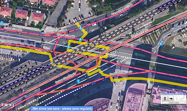
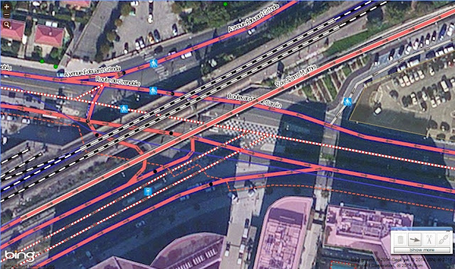
And finally, in the case of crossing Rene Cassin on the east side of the overpass, as far as OSM, the routing service and the app are concerned, there IS no crossing at that particular point. It’s not a feature on the map at this moment in time. But to illustrate how it needs to look in order for your route to work, I’ve gone into the OSM editor and drawn in the sidewalks and crossings. Compare it to the last screenshot I posted above.
Unfortunately I’m not going to save the changes to the database for 3 reasons:
- I had to make extensive use of Google Streetview to get my bearings and that’s against OSM’s principles.
- I don’t live in the area so I’d be an ‘armchair’ mapper and since there’s already someone else working in that area, I’ll leave it to them.
- I’m not convinced that OSM needs to focus on the routing of pedestrians and neither do many in the community. At this time, in order for routing to work properly for pedestrians, it requires mapping sidewalks as separate ‘ways’ creating what essentially amounts to a trail network along the sides of existing roads…yuck. This is viewed by many to be redundant (especially in an urban environment) and the hope is that in the future, proper tags can be developed and that routing servers will be able to correctly interpret them. It will take time for this to all come together. As it stands now, streets are basically assumed to have sidewalks on either side unless it’s a major highway. That’s why you were routed the way you were.
Thanks for your most recent screenshot; it clearly shows that the center bus lane is correctly labelled in OSM. You can see the telltale red circular warning signs on either side of the lane.
As to why it routed you across a street where there are clearly barriers, well OSM like most mapping datasets and routing services sorta assume that pedestrians can typically walk along the sides of most roadways (plus those barriers aren’t mapped). Again, OSM could be drawn with a level of granularity required to support much better pedestrian routing but I don’t think that’s a very high priority on most mappers to-do lists. I’m a heavy OSM contributor in my area and I rarely even give much thought to cycling routes as it’s not something I’m interested in nor is it something that’s too popular around here. You can infer from that how much thought I give to pedestrian routing.
As for the bus lane being tagged with “access=no”: that won’t prevent a crossing of that route, it simply prevents a router from generating a route along it. By placing that gray pin on that bus lane, you were essentially asking the router to generate a route along it and it came across the tag “access=no”. When it comes to navigation, a routing service can only plot a course along “ways” (a fancy word for lines on a map). So there needs to be a road, highway, path, track, stairs, bridleway etc. and they all need to be connected and tagged with the proper tags. A router won’t be able to simply “jump” you from the East to the West lane of Rene Cassin as it’s currently mapped. Now that I’ve looked at the map in the editor, I can see that someone has mapped some of the sidewalk and the crossings on the East side of the street but they haven’t completed making the connections to the West bound lane.

I’d do it myself except that the aerial imagery is not very good at that spot so it would be best to leave it to a local mapper with “on the ground” knowledge of the area. Luckily, a mapper has made changes to that exact footpath only 25 days ago so the area is actively being worked on.
It could very well be an incorrectly tagged; OSM isn’t perfect. Here’s a screen grab from street view that shows the driving lane in the foreground and the bus lane in the middle ground.

If the bus lane is in fact drivable by regular passenger cars, then yes OSM needs to be updated. Since OSM is a community driven effort, you can make the change yourself if you’d like by signing up or you can submit a report and a mapper in the area can take a look at it.
Here’s a screen grab from the OSM editor showing an aerial view; you can see the dotted red line which represents the bus lane. You can also see the separated East-West auto lanes on either side.
In regards to crosswalks, they are rarely mapped. They certainly can be but like most mapping databases, routing is primarily geared towards motorists. OSM does have OpenCycleMap geared towards cyclists but there’s no subset dedicated to pedestrians navigating city streets on foot. Even when crosswalks are mapped, they’re usually simple ‘nodes’ and I don’t think any routing service pays attention to them.
Ultimately, the reason one of your pins was ignored is simply because it was on the other side of Boulevard Rene Cassin and at that intersection, there’s no rout-able connection between the East and West lanes. At that intersection, cars can only make right-hand turns and head East. Basically, no connection, no access to the other side of the road as far as a router is concerned. In order for a routing service to navigate a crossing at that spot, a footpath would need to be drawn and tagged as “highway=footway” and connected to either side of the road. Again, that’s up to the mappers in the area and how dedicated and detailed they want to be.
Good to hear that you were able to finally see the OSM POI icons.
Concerning your routing issues, I believe the reason PE ignored one of the pins is because it’s placed on a street that is labelled in OSM as private access; that’s what the pink dotted line is representing. I just checked OSM and looks like it’s a bus lane as it’s tagged with these attributes:
access:no
bus:yes
highway:serviceThe “access:no” attribute will prevent any router (online or otherwise) from calculating a route over such a feature.
MikeB
Changing the map style to OpenStreetMap, you should definitely be seeing a difference as it uses the POI symbols from OSM.
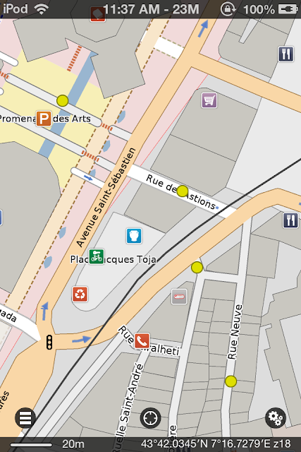
As for your routing idea about dropping Pins and having PE connect the dots, see my last post just above with instructions. Here’s an example of a 214m walking route in Nice I made using 4 Pins placed manually.

BTW, I didn’t realize there are zebras in Nice and that they have their own street crossings. I kid, I kid. 🙂
MikeB, in regards to your point #5, this can already be accomplished in PE using Pins. Let’s say you have 4 manually placed points you’d like to connect, do the following:
- Drop a Pin on the map as your starting point
- Drop your 3 additional Pins including your destination on the map as well
- Now tap on the starting Pin and tap the info bar at the top to bring up the details pane
- tap the route button and then choose “route from here”
- PE will now ask you to add a destination
- tap the info bar with the yellow exclamation
- tap “add destination”
- choose “select item on map”
- choose your next Pin and then tap the “+” symbol at the top-right and PE will generate a basic route
- you’ll still be looking at the details pane so now scroll down and choose “add another destination”
- follow from step 8 and add your remaining pins in the order you wish to build your custom route
I should also add that you’re not restricted to Pins; if you have POI’s along your route, you can use those instead and save yourself a bit of time. You can also use a combination of both or even street addresses, favorites and contacts as well.
Be advised that you can re-arrange the points of the route at any time by bringing up the route details screen and then scrolling down to the “route planner” section. Simply touch and hold the triple line icon to the right of each item and drag them around to whatever order you wish. PE will then re-generate the route accordingly
Thanks for following up, glad to hear you got it sorted. It sounds like you’ve got a pretty solid workflow should any issues arise in the future.
Great to hear you were able to get PE back up and running. Were you able to save your data or did I misunderstand? Good idea to backup the archive file of PE data either through iTunes or email.
BTW, were you able to get v2.2 to work or did you have to roll back to 2.1.1?
Oh right, if PE crashes immediately upon launch, it’d be kinda hard to backup your data. I have no idea how iCloud backups work, but it’s possible the data is there. May be worth a shot to roll back and then try to restore the data from iCloud. Hopefully @GeoMagik will see this thread and can offer better insight.
Well it’s good to know that your favorites weren’t lost in the upgrade to 2.2, otherwise that’d be a bug. As for the color of the star icon, I’d suggest starting a thread in the Feature Request section and perhaps the developers will be able to re-evaluate the change.
If it’s a bus stop, that means it was a POI (point of interest) already on the map and not a Pin that you added yourself. Open up the left-hand menu (on iPhone, iPod) and scroll down to the favorites section. You can choose either “All” or tap on “By Type” to expand the menu tree, and then choose “My POI”. If the bus stop in question is listed there, then you can be sure it’s been saved.
Another thing you can check is the “hidden” option. Find your POI and bring up the details pane; be sure the hidden toggle isn’t ON. If it is, it will disable the green outline around the POI icon on the map. For Pins, it will completely hide them from being displayed at all.
As for the color change, I can’t say for sure but if I had to venture a guess, I’d say the change is to be more in line with the direction Apple is heading; everything being flat, white and dare I say boring. The upcoming iOS 8 even features a monochrome mode that can make your device black and white?!! Why anyone would want a monochrome display in 2014 is beyond me but Apple has always tended to place a higher emphasis on form over function. Luckily it’s an option but it’s an odd choice seeing as there are so many other options they should be addressing first. Sorry for the rant, I’ll dismount my soapbox now.
Was the bus stop still listed under your “favorites” in the side menu? If so, it’s still saved. The star icon in the new PE is now solid gray when saved and simply a light gray outline when not. In previous versions of PE, the star icons were colored.
Sorry to hear about your trouble SJ. All may not be lost though; you may be able to roll back to the previous version by following the steps at this link:
http://www.iphonefaq.org/archives/971543
Be aware, that you should backup the data in Pocket Earth (PE) before deleting the new app from your iPad. You can do this by going into PE’s settings menu, under the Export-Import section, choose “export” and then “Export All Data:iTunes”. This will save an archive of the data that you can later re-import. You should go into iTunes right after this step to save the file to your PC’s desktop as deleting the app using the link above will also see iTunes delete this archive file. You can always copy it back to iTunes after you re-install the app. Also note that the archive doesn’t save map data, so you’ll need to re-download the maps.
This should only need to be a temporary measure as I’m sure the developers will be able to get you sorted out properly.
Interesting discovery about the layer attribute. One of the more frustrating tags in OSM; the Wiki clearly states:
“Bridges should have a layer=, for simple crossings almost always layer=1″*
Yet despite this wording, many choose to ignore it and most discussions on the topic are dominated by those who feel the tag is redundant and that by nature bridge should imply that it’s “over” some other object and that renderers should also assume this. Thus they map the bridge and leave the default at level=0.
So is this the cause of the overly thick trail bridges?
-
AuthorPosts